Recreational Land & Farm for Sale in Marlinton, West Virginia
Sunset Rd Marlinton, WV 24954
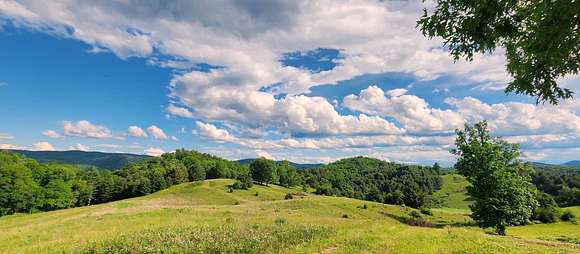
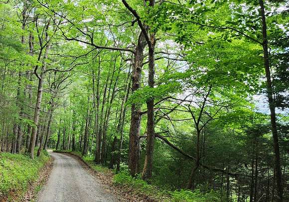


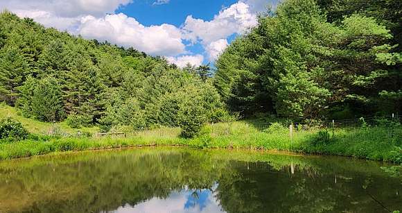


Grindstone Knob Field and Forest is a 219-acre classic multiple-use parcel located in Pocahontas County WV, recognized as "The Alaska of the East". This forever wild property adjoins the Monongahela National Forest, has 75 acres of meadows and 177 acres of rolling woodland. Grindstone is a "Dark Sky" candidate with little or no light pollution. Notably, Grindstone is located in the "Quite Zone" surrounding the Greenbank Observatory, home to the world's premiere single-dish radio telescope. HIGHLIGHTS *219 acre+/- classic multiple-use parcel located in Pocahontas County WV, the "Birthplace of Five Rivers" *Adjoins the Monongahela National Forest for about one quarter mile *Just 35 minutes to Snowshoe Ski Resort *Located in West Virginia's "Radio Quite Zone". This area offers substantial relief to those suffering from magnetic sensitivity. *Water resources include 3000 +/- feet of blue line streams, several ephemeral and intermittent streams, and a quarter acre farm pond *144 acres +/- of Appalachian hardwoods and Eastern white pine timber was recently selectively harvested. *75 acres +/- open pasture which would make a nice grazing boundary but currently is being used for soft recreational pursuits *The whole original property was surveyed in October 1997 *Property has been closed to the public for many years thus creating a nature sanctuary *Conveying with all timber, surface rights, and mineral rights in title *Long-term wildlife management with experienced forest stewardship *An abundant and diverse wildlife population *Some rock outcrops, moss & lichen covered field stone *Accessed by state-maintained roads *Networked interior trails provide access to nearly every corner of the property *Nearby Greenbrier River is perfect for anglers and water recreation enthusiasts *Long-range views approaching 20 miles *Commercially - operable ground supporting farming, forestry, recreation and future cabin sites *30 minutes to Snowshoe Ski Resort, Cass Scenic Railroad and Seneca State Forest *Varied topography with seasonal streams interspersed with flats and hillsides *Elevations range from 2,574' to over 3,100' *Electric service roadside *Low taxes, low population density, little or no light pollution *Perfect area for watersports, hunting, fishing, hiking, horseback riding skiing, motorcross *Dark Skies offer Stargazing-Planet Observation, Astrophotography and Star Walking *Birding: The property is an excellent site for birdwatching. Several square miles of forests and fields surround the farm providing a habitat for wood warblers, vireos, thrushes, chats, cuckoos, ovenbirds, and many other forest dwelling birds. The farm pond is attractive to waterfowl. *219 acres +/- sequesters tons of Carbon Dioxide and produces tons of Oxygen *Shopping and city/town amenities, hospitals available in Marlinton 25 minutes, Lewisburg one-hour, White Sulphur Springs 50 minutes and Elkins 90 minutes LOCATION Google Coordinates: 38.220038?(N), -79.945825?(W) Address: Sunset Road, Marlinton, WV 24954. A 911 address is not assigned to a property without structures. Elevation Range: 2574 ft. to 3166 ft. +/- Driving Times Towns Elkins: 1 hour 35 minutes Lewisburg: 1 hour 5 minutes Marlinton: 25 minutes White Sulphur Springs: 50 minutes Snowshoe 40 minutes FOREST/TIMBER RESOURCES The Grindstone Knob's 177-acre timber resource is composed of Appalachian hardwoods and Eastern White Pine. The forest has been well managed over many decades. Sections of the forest have been selectively harvested as prudent professional forest management guidelines called for. The last selective harvest was made in the year 2020. Timber Value of the timber and pulpwood has not been determined. The forest's predominately well-drained upland terrain has led to a resource dominated by hardwood and pine species. Overall, the species composition is desirable and favors Appalachian hardwood types.
Directions
Near Minnehaha Springs, Pocahontas County, WV Driving Destination Google Coordinates: 38.220038?(N); -79.945825?(W) From Marlinton, WV: 14.4 Miles +/- (25 Minutes +/-) From the bridge over the river in Marlinton, travel RT 39 East (passing through Huntersville) for 8.9 miles to Minnehaha Springs; turn left onto Route 92 North; travel 3.9 miles; turn left onto Sunset Road; travel 1.7 miles; the property road is on the right.
Property details
- County
- Pocahontas County
- Elevation
- 2,844 feet
- MLS Number
- MyStateMLS 11291274
- Date Posted
Property taxes
- Year not provided
- $158
Listing history
| Date | Event | Price | Change | Source |
|---|---|---|---|---|
| June 25, 2024 | New listing | $555,000 | — | MyStateMLS |