Image
Map
Street
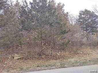
Residential Land for Sale in High Ridge, Missouri
High Ridge Mnr, High Ridge, MO 63049
$8,000
0.17 acres
Active
Est $124/moThis lot is located on Cedar Cir. in High Ridge Manor Resub.
3rd lot on the right as entering Cedar Cir
Location
- Street address
- High Ridge Mnr, Block 2
- County
- Jefferson County
- Community
- High Ridge Manor
- School district
- Northwest R-I
- Elevation
- 594 feet
Directions
HWY 30 to Carol Park Rd, Follow to Sycamore Ln. turn , to Brookside Pl. turn rt. ,to Cedar Cir. turn Right.
3rd lot on the right
Property details
- Lot size
- 0.174 acres7,579 sq ft
- Zoning
- Single-Family
- MLS #
- MARIS 24044893
- Posted
Parcels
- 03-7.0-35.0-2-004-027
Legal description
High Ridge Manor Resub Lot 3 Block 2
Nearby schools
| Name | Type | District |
|---|---|---|
| House Springs Elem. | Elementary | Northwest R-I |
| Northwest Valley School | Middle | Northwest R-I |
| Northwest High | High | Northwest R-I |
Listing history
| Date | Event | Price | Change | Source |
|---|---|---|---|---|
| July 22, 2024 | New listing | $8,000 | — | MARIS |
Payment calculator
Contact listing agent
By submitting, I agree to the terms of use and to be contacted by . Message and data rates may apply.