Land for Sale in Durbin, West Virginia
E River Dr Durbin, WV 26264

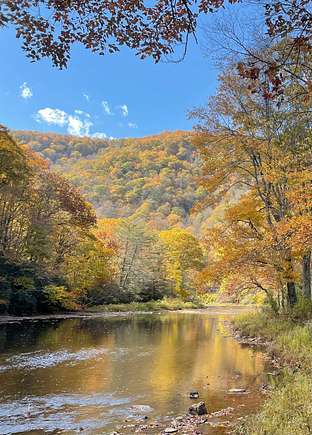

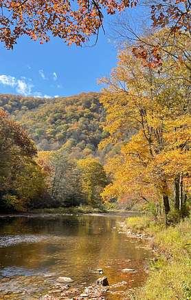

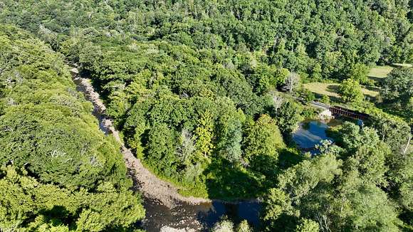


OVERVIEW Where the West Fork and the East Fork meet to form the Greenbrier River, sits this amazing opportunity to own the Greenbrier Beginnings @ Durbin. This well-situated tract of land contains 7.87 surveyed acres with frontage on the Greenbrier River and the West Fork Greenbrier River. The old home site area has continued to be very well maintained for decades and is ready for a new home, recreational cabin, or primitive camp site area. A mature bottomland forest with pine and spruce plantings along with native hardwood species combine to configure the remainder of the property. Assorted recreational opportunities abound near this wonderful tract of land in scenic Pocahontas County, West Virginia - "Nature's Mountain Playground." ATTRIBUTES AND HIGHLIGHTS *Approximately 1,750 feet of river frontage/access on the Greenbrier River *Approximately 335 feet of boundary in the center of the West Fork Greenbrier River *Perfect for anglers, water recreation and nature enthusiasts *7.87 acres surveyed in 2012 *2 acres +/- of maintained, well-manicured open land *Outstanding recreational opportunities nearby *Adjacent to the 921,000-acre Monongahela National Forest *United States Forest Service (USFS) Greenbrier District Ranger Station less than 5 miles away in Bartow, WV *Snowshoe Mountain Ski Resort approximately 30 miles away. *Numerous fishing watersheds close by including the Greenbrier River, Buffalo Lake, *Shaver's Fork of the Cheat, Seneca Lake and many more. *Train enthusiasts will enjoy the historic Durbin Rocket and the Durbin and Greenbrier Railroad System along with the nearby Cass Scenic Railroad. *The Greenbrier River Trail and the West Fork Trail offer nearly a combined 100-miles of old railroad grade designed for hiking, mountain biking, horseback riding and cross-country skiing. *The Green Bank Observatory, previously known as the National Radio Astronomy Observatory is nearby. *Located in West Virginia's "Radio Quite Zone." This area offers substantial relief to those suffering from magnetic sensitivity. *Shopping, city/town amenities and hospitals available in Marlinton, WV (50 minutes) and Elkins, WV (45 minutes) *Jet airports located in Lewisburg, WV and Bridgeport, WV *Four seasons climate - the autumn season is spectacular and summers warm and breezy LOCATION Google Coordinates: 38.544587 (N), -79.835884 (W) Address: East River Drive, Durbin, WV. A 911 physical address is not assigned to a property without structures Elevation Range: +/- 2,708' to +/- 2,719' Approximate Driving Times Towns Durbin, WV: Less than 5 minutes Elkins, WV: 45 minutes Lewisburg, WV: 1 hour 40 minutes Marlinton, WV: 50 minutes Snowshoe Mountain Ski Resort: 45 minutes Airports Greenbrier Valley Airport, Lewisburg, WV: 1 hour 40 minutes North Central WV Airport, Bridgeport, WV: 1 hour 45 minutes Recreation Snowshoe Mountain Ski Resort 45 minutes Cass Scenic Railroad State Park, Cass: 25 minutes Green Bank Observatory, Greenbank, WV: 15 minutes Seneca State Forest: 45 minutes Buffalo Lake: 20 minutes WATER RESOURCES Greenbrier Beginnings @ Durbin has approximately 1,750 feet of river frontage at the headwaters of the Greenbrier River. Additionally, the property boundary is found to be in the center of the West Fork of Greenbrier for approximately 335 feet. This makes a total of 2,085 feet of river frontage or approximately 0.40 miles. MINERAL RESOURCES West Virginia is one of the states in the US that has two separate ownership titles; those being SURFACE RIGHTS and MINERAL RIGHTS. All rights the owner has will convey with the property. A mineral title search could be conducted by a title attorney at the same time when the surface title search is being conducted. BOUNDARIES AND SURVEY Greenbrier Beginnings @ Durbin was surveyed by Professional Surveyor Leon G. Mallow in July through October 2010 with a last revision in August 2012.
Directions
From Marlinton: Take Route 39 East for approximately 5.25 miles and take a left onto Route 28 North toward Cass and Green Bank. Travel Route 28 North for approximately 15.4 miles and bear left to continue on Route 28 North. Travel another 15 miles and take a left onto Route 250 & 92 toward Bartow. Travel for 4 miles to and through the town of Durbin and take a left onto Grant vanDevender Road. Travel 1/3 mile and take a left onto East River Drive. Go 0.80 miles and cross railroad track to enter the property. From Elkins: Take Route 219 South for approximately 16 miles and bear left onto Route 250 & 92. Travel Route 250 & 92 for approximately 18 miles and take a right onto Grant vanDevender Road before entering the town or Durbin. Travel 1/3 mile and take a left onto East River Drive. Go 0.80 miles and cross railroad track to enter the property.
Property details
- County
- Pocahontas County
- Elevation
- 2,717 feet
- MLS Number
- MyStateMLS 11337124
- Date Posted
Property taxes
- Year not provided
- $112
Listing history
| Date | Event | Price | Change | Source |
|---|---|---|---|---|
| Sept 3, 2024 | New listing | $220,000 | — | MyStateMLS |