Skip to main content
Skip to navigation
Properties
Find agent
Post listing
Log in
•
Sign up
Search here
List
Blue Ridge, TX land for sale
Price
Size
Tags
Save
480 properties
Updated
For you
Newest
Price: high to low
Price: low to high
Size: large to small
Size: small to large
Updated
$29.9k drop • Feb 1
$70,000
0.28 acres
Fannin County
Leonard, TX 75452
15 days
$12k drop • Feb 18
$557,900
3 acres
Hunt County
4 bd, 3 ba
•
2,600 sq ft
Farmersville, TX 75442
$50k drop • Dec 6
$689,000
2.7 acres
Collin County
4 bd, 3 ba
•
3,094 sq ft
Princeton, TX 75407
3 months ago
$1,189,000
1.79 acres
Collin County
4 bd, 4 ba
•
3,959 sq ft
McKinney, TX 75071
10 days
$1,232,777
2 acres
Collin County
5 bd, 5 ba
•
4,123 sq ft
Anna, TX 75409
19 hours
$90,000
1 acre
Hunt County
Celeste, TX 75423
$5k drop • Feb 21
$75,000
0.97 acres
Collin County
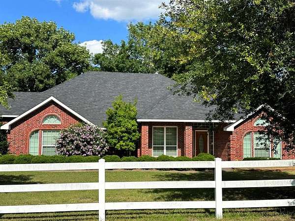
Blue Ridge, TX 75424
1 day
$750,000
5.29 acres
Collin County
8 bd, 7 ba
•
3,665 sq ft
Leonard, TX 75452
$25k drop • Jan 18
$1,399,999
10.3 acres
Collin County
4 bd, 4 ba
•
3,231 sq ft
Anna, TX 75409
10 days
$725,000
18.3 acres
Hunt County
2 bd, 2 ba
•
1,476 sq ft
Leonard, TX 75452
16 days
$885,000
12.3 acres
Fannin County
4 bd, 3 ba
•
2,400 sq ft
Leonard, TX 75452
36 days ago
$1,750,000
12.3 acres
Collin County
4 bd, 3 ba
•
2,936 sq ft
Princeton, TX 75407
24 days
$450,000
6 acres
Grayson County
2 bd, 2 ba
•
1,510 sq ft
Whitewright, TX 75491
3 months ago
$594,500
2 acres
Fannin County
4 bd, 3 ba
•
2,000 sq ft
Leonard, TX 75452
9 months ago
$695,000
3.24 acres
Collin County
4 bd, 3 ba
•
2,606 sq ft
Anna, TX 75409
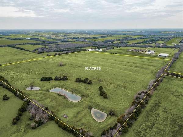
1 day
$1,554,800
52 acres
Collin County
Blue Ridge, TX 75424
Pending
Under contract
$1,650/mo
5.38 acres
Collin County
3 bd, 2 ba
•
1,848 sq ft
Farmersville, TX 75442
1 day
$1,100,000
10 acres
Collin County
3 bd, 3 ba
•
2,552 sq ft
Leonard, TX 75452
3 days
$1,250,000
12.1 acres
Collin County
Farmersville, TX 75442
1 day
$847,000
26.5 acres
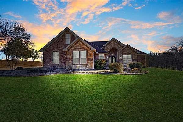
Collin County
Blue Ridge, TX 75424
1 day
$749,000
25.5 acres
Collin County
Blue Ridge, TX 75424
1 day
$1,125,000
17.7 acres
Collin County
4 bd, 3 ba
•
2,526 sq ft
Blue Ridge, TX 75424
1 day
$875,000
14 acres
Collin County
Blue Ridge, TX 75424
1 day
$499,000
12.6 acres
Collin County
Blue Ridge, TX 75424
1 day
$2,500,000
47 acres
Collin County
4 bd, 3 ba
•
2,526 sq ft
Blue Ridge, TX 75424
3 months ago
$112,000
1 acre
Grayson County
Van Alstyne, TX 75495
$2m drop • Feb 20
$6,400,000
34.2 acres
Collin County
Melissa, TX 75454
$23.5k drop • Nov 25
$349,900
2 acres
Hunt County
3 bd, 2 ba
•
1,987 sq ft
Farmersville, TX 75442
6 months ago
$599,000
6.88 acres
Grayson County
2 bd, 1 ba
•
1,400 sq ft
Whitewright, TX 75491
Pending
Under contract
$535,000
1.5 acres
Fannin County
4 bd, 3 ba
•
2,353 sq ft
Trenton, TX 75490
2 months ago
$665,000
6 acres
Fannin County
4 bd, 2 ba
•
3,007 sq ft
Leonard, TX 75452
Pending
Under contract
$330,000
10 acres
Fannin County
Trenton, TX 75452
2 months ago
$594,000
16.6 acres
Fannin County
Leonard, TX 75452
$101k drop • Feb 20
$999,000
43 acres
Hunt County
Celeste, TX 75423
2 days
$1,400,000
6.13 acres
Collin County
— sq ft
Farmersville, TX 75442
2 days
$477,000
7.75 acres
Hunt County
3 bd, 2 ba
•
2,105 sq ft
Celeste, TX 75423
2 days
$1,499,900
11.7 acres
Hunt County
5 bd, 5 ba
•
5,765 sq ft
Celeste, TX 75423
Pending
Under contract
$3,800,000
314 acres
Fannin County
Trenton, TX 75490
2 days
$395,000
4.68 acres
Collin County
Farmersville, TX 75442
2 days
$205,000
1 acre
Collin County
Anna, TX 75409
$10k drop • Feb 20
$215,000
10.2 acres
Hunt County
Celeste, TX 75423
2 days
$159,000
3.3 acres
Hunt County
Celeste, TX 75423
2 days
$749,000
2.78 acres
Fannin County
3 bd, 2 ba
•
1,963 sq ft
Trenton, TX 75452
3 days
$190,000
2.85 acres
Collin County
Blue Ridge, TX 75424
3 days
$190,000
2.87 acres
Collin County
Blue Ridge, TX 75424
3 days
$380,000
5.72 acres
Collin County
Blue Ridge, TX 75424
$50k drop • Feb 18
$1,299,000
18.7 acres
Fannin County
4 bd, 4 ba
•
5,060 sq ft
Trenton, TX 75490
Pending
Under contract
$1,370,000
6.5 acres
Collin County
4 bd, 3 ba
•
4,064 sq ft
Anna, TX 75409
$1k drop • Feb 19
$60,900
0.24 acres
Collin County
Blue Ridge, TX 75424
7 months ago
$629,900
1.58 acres
Hunt County
4 bd, 4 ba
•
3,097 sq ft
Celeste, TX 75423
1
2
3
4
…
10
1-50 of 480 properties
Map